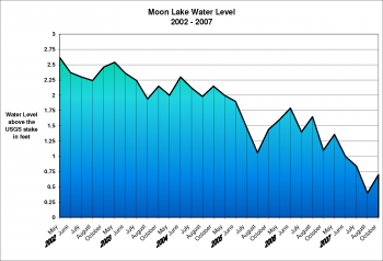
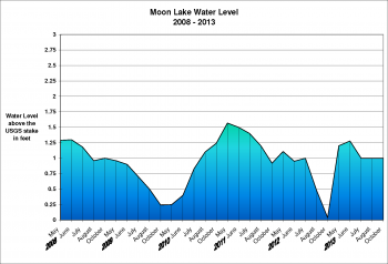
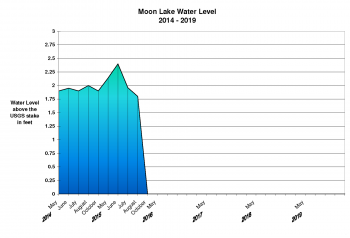
A stake was placed in Moon Lake on September 27th, 2001 by the United States Geological Survey (USGS).
On that day the altitude of the top of the stake was 1614.26 feet above mean sea level.
All measurements are in feet above the USGS stake in calm water.
NOTE: Previous levels (1984 – 1995) were read on a USGS stake in Alma Lake
Moon Lake Water Levels
Year May 28-31 June 22-30 July 21-28 August 23-31 October 7-16
2019
2018 3.58 4.04 3.87 3.81 3.83
2017 3.66 4.00 4.00 3.62
2016 2.30 2.30 2.44 2.50 2.46
2015 2.14 2.40 1.96 1.80 2.00
2014 1.90 1.95 1.90 2.00 1.90
2013 1.20 1.28 1.00 1.00 1.00
2012 1.11 0.95 1.00 0.48 0.04
2011 1.57 1.50 1.40 1.20 0.92
2010 0.25 0.40 0.83 1.10 1.24
2009 0.96 0.90 0.70 0.50 0.24
2008 1.29 1.30 1.18 0.96 1.00
2007 1.36 1.00 0.84 0.40 0.70
2006 1.60 1.79 1.40 1.65 1.10
2005 2.00 1.90 1.48 1.06 1.44
2004 2.00 2.30 2.12 1.98 2.15
2003 2.54 2.36 2.24 1.94 2.15
2002 2.62 2.37 2.30 2.24 2.46
While trends can be seen in the above numbers, they are sometimes more easily understood by viewing a graph.
Here are some graphs of the above data. All graphs are in the same scale for easy comparison year by year.
For a printable view of any graph, click on the graph.